Mapping Workshop and Reflection
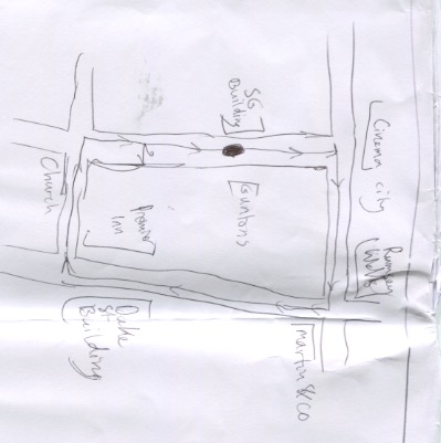 In this workshop we were instructed to take a short walk in the city to wherever we wanted and take in our environment on the journey. When we got back, we were instructed to quickly draw a map, guiding the directions to the destination of the walk we went on, after that, we discussed the important components that make a map usable and efficient. We talked about keys, colour coding, landmarks, arrows, proportion, etc. and how each of these components can turn a scribble of some lines on a page to a helpful guide people can use to reach the desired destination. Following this discussion were told to create a second iteration of the map, introducing as many of these components as we can. At this point I recreated my map with the inclusion of a key and a more detailed, proportionate illustration of the area I traveled and the roads around it. The task set at the end of the workshop was to create one final iteration of the map. For this I decided to make it on PC rather than hand drawing it so that it could be a better quality illustration and so I could include more clear details. My first idea for this iteration was to include photos of the landmarks on the map to further guide a user around the map. Also, using a computer to make the map would make colour coding it much easier.
The final iteration of the map was made on Adobe Illustrator, and as this was my first experience with the software, I feel as though this was a pretty successful project. This iteration of the map consists of : a Key, photographs of the landmarks, colour and a more accurate, detailed version of the area. I feel as though this iteration does a far better job at providing the viewer with the information they need to take this journey, and is also a lot more aesthetically appealing to viewers than the first and second iterations.


Comments
Post a Comment